Geography.
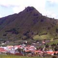 Located on the northern part of the isle with a surface area of 26,41 Km 2, at an altitude of 400m. It has a population of 9 948, and is 16 Km from Santa Cruz de Tenerife by road.
It’s most eastern point is located among the foothills of the Anaga massif, descending towards the south up to the Mesa Mota, and continuing westwards until Montaña del Púlpito, El Portezuelo and El Picacho de Los Lázaros. In its northern sector, it includes a large part of the Mesa de Tejina, continuing the boder up to the top of the Moquinal, in the aforementioned Anaga area. The most ancient geological materials located in the area belong precisely to this ancient massif, that corresponds to the first volcanic cycle of the island’s formation.